       |
|
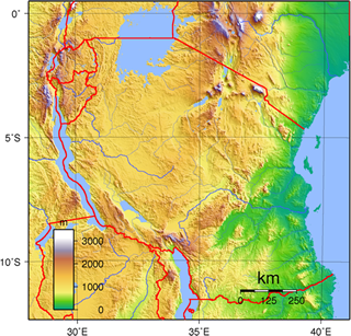
You are here > Tourism > Statistics > Topography Tanzania's Topography The country includes the islands of Zanzibar and Pemba, and other offshore islands in the Indian Ocean. Great Rift Valley Topography The landscape of mainland Tanzania is generally flat and low along the coast, but a plateau at an average elevation of about 1,220 metres (4,003 feet) constitutes the greater part of the country. Isolated mountain groups rise in the northeast and southwest. The volcanic Kilimanjaro (5,895 metres/19,341 feet), the highest mountain in Africa, is located near the northeastern border. Zanzibar is the largest coral island off the coast of Africa. Pemba is some 40 kilometres (25 miles) northwest of Zanzibar. Both Zanzibar and Pemba are mostly low-lying.
|
|


 Location


